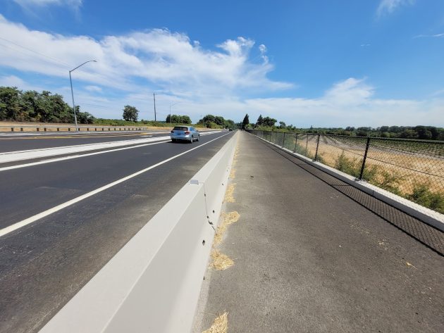
Looking toward Albany on this section of what may become the Albany-Corvallis multi-use path.
It was early in August when I took this photo. It’s on the south side of the new configuration of Highway 20 at Independence Highway, an ODOT safety project that had just been completed.
The paved pathway to the right of the Jersey barrier is supposed to serve as a section on the long-planned Albany-Corvallis bikeway and pedestrian path. As far as I know it’s the only section that’s finished.
I eyeballed the width at about 12 feet and guessed at the the length on a Google map, more than 1,000 feet. If it ever gets used, this section will be a fine way for walkers and bike riders to cross the low-lying draw below the highway. (It’s unlikely many walkers would find themselves in that spot, four miles from Albany and six from downtown Corvallis.)
There have been many changes in the planning for this non-motorized transportation route, which has been talked about since then-Benton Commissioner Linda Modrell proposed it about 20 years ago. It’s hard to keep up with the process.
But the Oregon Department of Transportation has posted information on what it calls Project No. 18850, the “Corvallis to Albany Trail: Scenic Drive to Spring Hill.” That’s the Albany end of the 10-mile route.
According to that posting, ODOT is “responsible for the contract and delivery” of the project. This includes completion of a review under the National Environmental Policy Act, purchase of right of way, and construction of the “off-highway multi-use path.”
The department says the project is still in design and will go to bid on Jan. 23, 2025. The estimated cost of this leg is about $2.8 million, of which $591,731 has been spent “to date.” (The posting includes no date, though.)
A drawing with the posting shows the path following the highway. So apparently the idea of routing it through back yards north of the highway has been sensibly abandoned.
Since the new segment at Independence Highway is on the south side of the road, presumably the ODOT designers want to put the Albany leg on the south side too. Otherwise they’d have to plan on two or more bridges across Highway 20, where motor traffic flows at near freeway speeds.
Whether the entire route between Albany and Corvallis ever gets built is impossible to know. But the planning keeps going on. (hh)

It’s a start. Can’t wait until the entire distance is completed. That’s a good ride but that new infrastructure looks so much safer.
I like the new setup at Independence and Hwy 20, but there will still be accidents there and here is why. When a person is heading south on Independence and going to turn left onto Hwy 20, they will be looking left and probably not think about the left turn lane on Hwy 20. I have witnessed people turn left at break-neck speeds. Maybe the left hand turn lane, off of Hwy 20, should have a STOP sign. No matter what you do to improve things, there are those bound to kill themselves on it.
I thought it was another example of poor planning. I guess that depends upon what your objective as to what the goals should be? If you ever travel from Corvallis to Albany you know the traffic is so heavy that it takes 40 minutes to cross the bridge into Albany. So the question should be what is the goal, to slow down traffic or to move more traffic across this bottleneck? I vote for the latter of the two.
Very interesting article – also interesting that so far ODOT has not spoken to landowners on the south side of the highway… I would think that would be part of the overall planning process. Silly me thinking ODOT would consider speaking with landowners. Good thing we have you Hasso!