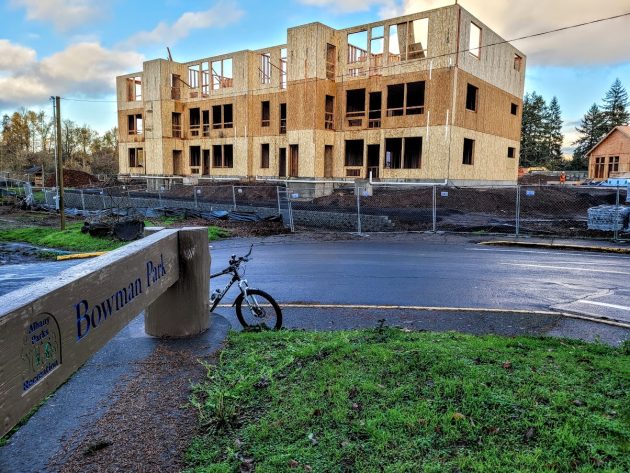
Here is The Banks’ Building No. 2, a 12-unit apartment building, under construction on Nov. 23.
If you haven’t been to Bowman Park in Albany since the summer, you may be surprised, the next time you go, by how the view at the entrance to the park has changed.
As mentioned here now and then, a Salem contractor, C.D. Redding Construction Inc., is building “The Banks,” a 120-unit apartment complex on the Willamette River at 595 Geary St. N.E. That’s across Geary Street from Bowman Park.
The first building to go up was the one-story clubhouse, to the right of the future entrance to the complex from Geary Street. Building No. 2, a three-story 12-plex to the left of the entrance, towers over the approach to the park.
The 120 apartments will be in eight buildings, two of them holding 24 units and the rest 12 units each.
Building permits on file at the city tell you a little about the amenities. Building 3, for example, which will look out over the parking lot bordering the riverbank and the Willamette River itself, will have 18 apartments with two bathrooms each, according to the plumbing permit. In the other six other units, tenants will have to do with one bathroom each.
Here’s something else you can tell from the building permits. The Salem developers of this project paid the city about $834,000 in fees and systems development charges. (Not counting fees for electrical and plumbing permits and other incidentals.)
Each of the individual permits for the buildings repeats some of the conditions for approval of the site plan. Among them: The development must set aside a 16-foot-wide easement for a multi-use path between the riverbank and the complex.
The path, shown in the plans as 10 feet wide, will replace the unimproved dirt trail that now connects Bowman Park with Simpson Park downstream. Between the path and the parking lot on the land side, there is to be a strip of open space about 20 feet wide.
During the summer, an archaeological dig at the construction site stirred up a bit of interest. It was done by Willamette Cultural Resources Associates, with offices in Seattle and Portland. I asked about it by email. Eventually one of the principals in the Portland office emailed me back, regretting that because of state law, he couldn’t tell me what if anything they found.
Score another one for the transparency that Oregon often claims. (hh)


Your comments about secrecy raise a few questions.
ORS 192.501(11) says PUBLIC records related to archaeological sites or objects are exempt from disclosure.
But this dig is on private land.
The landowner owns the archaeological site.
The landowner owns any artifacts found, except for Native American human remains, burials, associated funerary objects, sacred objects, and objects of cultural patrimony.
Given the apparent secrecy involved, should we assume that the objects found are Native American?
But even if the objects are Native American, that only means the private landowner does not own them.
The private landowner should still be free to share private information and private records. They paid for the info & records and they own the site.
Does the law or permit impose a secrecy requirement on PRIVATE landowners and their PRIVATELY owned info & records? If so, that seems like an unjustifiable intrusion on private property rights.
https://www.oregon.gov/oprd/OH/Documents/Bulletin1.pdf
Give it up Gordon. Nobody cares about your myoptic fixations.
@Bob Wood, I liked Mr. Shadle’s exposition, albeit a more judicious peppering of ALL CAPS would improve the polemic.
My trail led to the Oregon Archaeological Records Remote Access (OARRA)
https://www.oregon.gov/oprd/OH/Pages/Database-and-Mapping-Resources.aspx
to see if anything turned up, but I’m not a ‘qualified archeologist’ and access is denied.
Anyway, $834k in fees/SDC’s will fill some potholes, certainly.
I recall that area around Bowman Park fondly, when we lived on First Ave and would walk our dogs behind the Cemwood plant to track the Comet Hale-Bopp.
1) The reason the general public doesn’t have access to those archeological records is because there is a long history of sites being illegally ransacked by people.
2) Those SDC fees can’t be used to fill potholes and other “maintenance” activities. They can only be used for major projects that increase the capacity of the “systems” resulting from ongoing development. Somebody from Public Works could give you a more specific definition if you ask, or it may be on the city website somewhere.
Maybe they found Bigfoot
So..has anyone come up with a solution for what I see is a monumental traffic jab at Geary & Salem?? Too many square pegs (cars) into a round hole (street).
In the fullness of time a traffic light will be installed.