

This long unused railroad spur ends just before Washington Street. (Photo 3/22/2025)
For many years, a remnant of a long unused railroad spur has been visible on the west end of Water Avenue at Washington Street. Before this artifact of Albany’s history disappears forever, I tried to find out where it led back in the day.
Some time this year the contractor for the Albany Waterfront Project is going to tear up that end of Water Avenue in order to rebuild it as what city officials call a “plaza street” suitable for public events and such. I am assuming the old rails will have to go.
I’ve been wondering about that spur for years, that is, every time I pass it on my regular bike rides along the Albany riverfront. Where did the track once lead? How long has it been there?
Old maps might hold a clue.
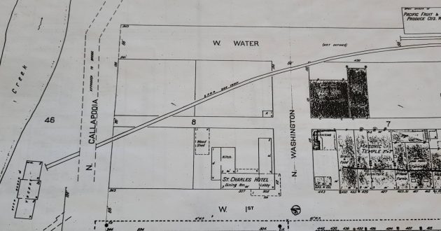
This is from a Sanford fire insurance map from 1925, on file at the Carnegie Library downtown.
As you can see from the image above, in 1925 the rail spur apparently was part of the Southern Pacific system. It crossed Washington Street and extended across vacant property behind the St. Charles Hotel to what the map labeled a vacant building off the north end of Calapooia Steet.
(A hundred years ago, they spelled it “Callapooia” and they also thought of the waterway on the west side as only a creek, not a river.)
It’s hard to make out, but those blacked-out buildings on the corner of Washington and Water were labeled on the map as a feed mill and a furniture wherehouse. Those buildings might have been destinations of freight traffic on the spur.
At the Albany Regional Museum, I came across an older map of the same part of town.
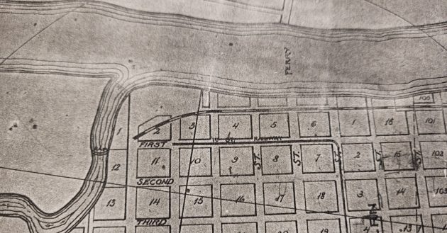
I found this in the collection of maps at the Albany Regional Museum, a very useful resource.
This map is from 1890 and describes “The City of Albany, the Great Railroad Center of the North West.”
The map lacks details of structures on the ground, but it does show a railroad line in the same location as our old spur. And the line ends pretty much in the same place as on the map from 35 years later.
You might notice that in 1890, Albany had a “street railway” along First Avenue, a line that then made a turn south toward the railroad depot.
As for the spur still visible, I don’t know how long it was in use and when it was abandoned. But the maps make me think those rails are at least 100 years old. And maybe they date back to 1890 or before.
When the “plaza street” is built, it will probably look all spiffy and new. But it won’t remind anyone of the Albany riverfront’s long industrial past. (hh)

Nice piece of history, Hasso. Kind of hate to see rail lines disappear. Once they’re gone they’re gone forever. Just like Brownsville’s old line.
I can remember the old feed mill that was on Water St between Ellsworth and Broadalbin. That would be another customer for the rail line. The feed mill might have received grain shipments by rail from the valley and loaded the shipments on barges on the Willamette river from a dock at the feed mill. There was also the ice plant behind the post office. Ice would have been transported by rail to Albany from Sweet Home and east (I think there was a rail line that ran over the Cascades in the late 1800s / early 1900s). Perhaps ice was also transported on the river.
Why not find a way to preserve that reminder of our past and incorporate the tracks into the new design?
Speaking from the memory of long ago I believe this track may have been part of what extended in a general southerly direction and was behind, among other buildings, the Copeland Lumber yard which faced Calapooia and possibly 1st and 2nd Avenues and dead ended against the north end of Albany Ice and Cold Storage which fronted on 3rd and the west side on the Calapooia River east bank. There was covered bridge leading to Bryant way and Bryant Park.
Albany Ice and Cold Storage was used for storage of frozen foods and also had an ice plant where one could purchase any size block from 5 lbs to 400 lbs. It was also used to ice refrigerated “ice cars” for movement of frozen foods – no mobile refrigeration units at that time. Frozen berries were shipped in wooded barrells and weighed somewhere around 400 lbs each.
I worked there in the summer of 1951, right out of high school and was paid a whopping $1.75 per hour.
AAAH the good old days
“the St. Charles Hotel” (where the Carousel now stands) is also fairly prominent on the Chamber of Commerce mural across the street from the Carousel…
Thank you! Having grown up here in Albany, I have often wondered about those old tracks. I appreciate learning a bit more of the history of Albany.
Back in the early 1960’s, I worked weekends at the Venetian Theatre, and I was told by the “old timers” there that once upon a time the theatre building was used for vaudeville acts and similar traveling performances. The railroad behind the theatre building was used to transport scenery, props and actors. I understood that occasionally, circus animals were part of the action. I had the chance to check out the stage of the Venetian, and discovered quite a deep and useful area in front of and behind the movie screen. Not sure this is all true, but it seems logical to me.
It’s correct that in 1925 the spur was an appendage of Southern Pacific, but its genesis was in the 19th century. After the Oregon Pacific Railroad bridged the Willamette River to build into Albany in 1887 the spur was constructed to reach businesses along Albany’s waterfront, including a warehouse and dock operated by OP. In 1895 the OP became the Oregon Central & Eastern Railroad, and in 1898 it was reorganized as the Corvallis & Eastern Railroad. The C&E was absorbed into Southern Pacific in 1915,
Thanks Hasso for another grateful article on Albany’s local history. It would be such a shame to totally remove the all rail evidence of that historic area. History should be embraced as it gives our community uniqueness. I’ve always wondered why there hasn’t been much of an effort to recreate some of the earlier buildings that were once along the river? I’m sure it will all look nice when completed, but it will look like all the other modern river front projects. At the very least, the city could but up some signage to let people know of it’s past.
The building that had been Ciddicci’s Pizza was a train station at one time. How did it tie into those other tracks that all of you have mentioned. Thanks for the history lesson of Albany. So interesting when folks remember these things to share with all of us.
The Oregon Electric Railway depot you mention opened in 1912 on the OER rail line down Fifth Avenue. It was not directly connected to the waterfront rail spurs operated by other companies.
Thanks for the additional information. My husband said he remembered the OER going through Harrisburg where he grew up. So much history in our area. It’s amazing if you just look a little deeper.
Looking at the 1884 and 1898 Sanborn maps (available at Loc.gov), the rail line is shown as the O&C RR, ending at the Magnolia Flour Mills RR freight dock. The mill is on the Calapooia River, with a dam across at the end of First St, showing on both maps, image 1. In 1884, the RR had a siding “for grain cars only”, between Washington and Ellsworth. by 1888, there was only a siding for the (non-operating) Albany Flour Mill, which sat on a wharf. There were also RR spurs between Ellsworth and Lyon, serving the OPRR wharves & Warehouse.
A surprising find in (1888) map 2 was the C L Brush’s Wire Mattress Factory on the river at Lyon street, described as having “No Watchman, 2½ dozen hand grenades”
[https://www.loc.gov/resource/g4294am.g4294am_g073131888/?sp=2&r=0.535,0.124,0.535,0.443,0]
A “fire grenade” refers to a type of antique fire extinguisher, typically a glass bottle filled with a fire-retardant liquid (often carbon tetrachloride) designed to be thrown at the base of a fire to extinguish it
…. wherehouse. ?