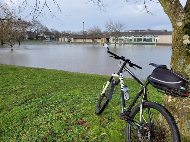
When it’s not a lake, this open area is the playground and lawn behind Periwinkle Elementary School.
On social media I read about a great big puddle behind Albany’s Periwinkle Elementary School. On Wednesday the bike took me there so I could see it for myself.
Here’s my report from the scene:
Now as puddles go, that’s a big one. Makes you want to break out the canoe.
To get there, I took the Periwinke Bikepath south from the corner of Geary Street and Queen Avenue.
The path leads through Periwinkle Park, winding through the park on a small rise that separates the school grounds from the permanent pond in the park.
On the way back, I took the northern section of the bikeway from Queen Avenue to near Lowe’s on Oak Street. Along that stretch, I could not help but notice that the traces of vagrants’ camps, so prevalent during the summer and fall, had all but disappeared.
I don’t know who cleaned it up. Whoever it was has the appreciation of everybody who uses that path for transportation and not as a place to camp out. (hh)


we got campers next to us at riverbend apts can hear em f… and fightin at nite we just watched a bunch a cops roll up on em thought sumthin was bout to go down but they just bounced out lol
Good job HH…. Your truthful reporting along with appropriate comments are real assets to us. Thanks for your diligence and reporting!
I’ve walked this path for the last 20 years with winters that have had more rainfall than this year so I’m curious to what has changed…..
And I have noticed that the water hasn’t pooled in other usual places such as on the path just west of the weir and on the cut-through to the cul-de-sac where it intersects the path. I thought that was a little weird when I first noticed it.
FWIW
I’ve lived in Albany all my life and my grandparents owned a small 20 acre farm just South of where Periwinkle Creek heads West for a short ways. The farmland North of where the creek bends was flat and at the same elevation as on the South side. The slight rise on the North side was bulldozed to make the area more park like. So….there’s now a low area and no where for the water to go during hard rains.
Before South Albany was developed a lot of the fields looked like lakes in the winter because the clay level is not too below the surface which doesn’t allow for much drainage.
In fact, a little further North where Periwinkle crosses through a culvert there was a small bridge close to the Geary Street and Queen intersection which was a little lower than the surrounding fields and would always flood during lots of rain. The only reason it doesn’t flood there anymore is that the city has built up that area and put in a culvert.
Thanks Hasso for the weather report at Periwinkle. What a mess the grass will be for a long time to dry out. Good to see you out!