For a second there it looked as though an early version of the Enterprise-class starships had landed on Takena Street in Albany’s Broadway Neighborhood. But just for a second. Or less.
A resident in that block off Ninth Avenue told me what it was, and a quick Internet search for the manufacturer’s name confirmed what he said.
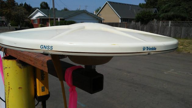
The Trimble company makes electronic positioning systems for the surveyor’s trade. And this item looks kind of like a geodetic antenna shown in the company’s online ad. “Our survey & GIS solutions streamline workflows to optimize your productivity,” says the company, headquartered in Sunnyvale, CA.
The equipment on Takena, complete with a marine battery to keep it powered up, was installed in connection with the reconstruction of the western five blocks of Ninth Avenue. Presumably it helps the construction crew pinpoint exactly where different elements of the project were to be installed.
At the end of each workday the portable gear is taken away.
Is this all that fascinating? Not really. But it’s the sort of thing you see and wonder about, briefly, when you and your bike cruise Albany Streets and look around. (hh)
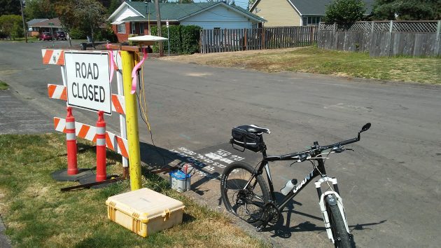
A wide shot, to show the dimensions of this contraption on Takena Street.

“Is this all that fascinating?”
To me it’s been a major obsession on-and-off for years. “GNSS” (printed on the antenna — Global Navigation Satellite System) is the generic name which includes American GPS, and systems from Russia, China, and Europe (in historic order). They not only compete but also combine to give more precise and reliable measurements than any one system could by itself. Many cars and cell phones now combine 2 or 3 of these systems to partially solve the most vexing problem — getting reliable readings in urban “canyons.”
The accuracy of survey-grade units is now down to a few (maybe 2 or 3) centimeters in good conditions, relative to a fixed “standard” location which can be several kilometers away. Cheap consumer grade is down to 2 or 3 meters, also in good conditions. Good enough to make street maps, but not good enough (or reliable enough) for self-driving cars.
An obvious remarkable thing is the accuracy compared to the satellite distances (roughly 20,000 km above ground). A less obvious one is that the units (like the one in your cell phone that adds only a few dollars to the cost) are able to extract incredibly tiny received signals buried in much more powerful noise and interference. It almost seems to violate some law of physics (repetition is the secret).
We were first. Something to be proud of on this July 4th. Sure beats setting off made-in-China fireworks and spreading pollution and disease.
H. C., you talk sooo much like a politician often times. Lot’s of words & not much said. Accuracy, both in the military & construction is a very necessary item. That is what this item is used for. Off a foot is as bad as off a mile! AND, how is shooting off fireworks “spreading disease”?? The smoke pollution I can see…but?
I’ve seen these before in the neighborhood and also wondered what they were. Thanks for the write-up!
The Trimble company has been a major provider of global positioning equipment to the agricultural industry for about 25 years. It is a system of triangulation that originated with the mariners of old. Celestial navigation calculated a boat’s position by figuring the angle / distance relationship between a star, the horizon and the watercraft.
The first equipment / systems we farmers used in late 90s involved plotting a course using a signal from a satellite, a fixed transmitter and the receiver in the tractor. It would allow the tractor driver to set a course and follow a heading that was displayed as a light bar, a series of dots with a center dot showing the desired course, and dots to left and right showing the deviation from that course.
Today, many farmers have fairly permanent markers in their fields where they position their own transmitter as the fixed point (horizon) and use a dozen or so satellites and their tractor receiver to complete the triangulation. Then the computer takes over and steers the tractor, swather, combine or tillage equipment.
As an old, and now retired farmer, I think this is an unfair advantage. We used to pride ourselves in how straight we could plow a furrow. I was taught to pick two points in the distance; a fence post at the other end of the field and a point on a tree-line beyond or a mountain peak, etc, and keep them all in a line. Unfortunately I more often picked a cow and a cloud and didn’t win very may prizes. Now straight furrows and crop rows are almost automatic.