If you didn’t know better, you might not recognize this sign as announcing an exit for Albany.
When you drive north on Interstate 5 and come to Exit 228, you’re already in Albany. For years now, I have wondered why the Oregon Department of Transportation does not say so on its sign.
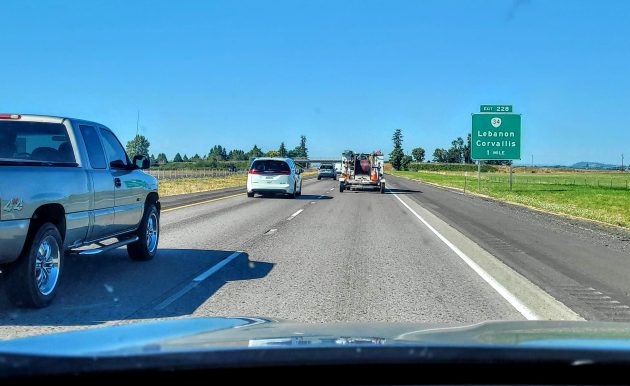
That sign is, of course, one mile ahead of the I-5 interchange with Highway 34. As you know and as the photo illustrates, the exit sign tells drivers that this is the place to get off if they’re headed for Corvallis or Lebanon.
Corvallis is 10 miles off the freeway to the west. Lebanon is seven miles the other way.
To get to the first official Albany exit, you have to stay on the freeway for another five miles until you reach Exit 233 on Highway 20, the Santiam Highway.
But in fact, you’re already in Albany by the time you reach Exit 228, at least as far as the post office is concerned. All the businesses around the Highway 34 cloverleaf have Albany addresses. That includes the UPS Albany Center, right there at the interchange on Olson Road S.E.
Everybody who lives around here knows all this. In order to get to most places in south and west Albany from the south, the quickest way is to get off I-5 at the “Corvallis-Lebanon” exit.
But suppose someone new comes along hoping to visit someone near South Albany High School without relying on GPS. The state’s freeway signage would send them on an unnecessary detour of seven or eight miles.
Maybe somebody in ODOT has an answer for why the agency has failed to put an accurate sign on this Albany off-ramp. If there is a reason, I’d like to know what it is. (hh)

It is after all the “Corvallis-Lebanon highway”. Using the standard of measuring mileage based on the “center” of the city, you’d be hard-pressed to say Highway 34 gets you anywhere near the center of Albany. Highway 34 does however lead you to the center of both Corvallis and Lebanon more so than Albany. It seems entirely logical to me.
This is a sign that the Deep State has it in for Albany. Perhaps Chavez-DeRemer can open a Federal investigation. Or, more locally, perhaps Boshart-Davis can do something. She’s a back-bencher with little power or ability to make a difference. Albany residents are weary of being ignored on Freeeway signage. One of these Representatives should get on this issue quickly before it metastasizes.
Huh??
It’s gonna be ok man
What in the world are you going on about??
My perspective of this is that signs are guides not absolutes. The priority of this exit is to convey that if you are looking for Lebanon or Corvallis, this exit is the most direct route to those areas. “Do not miss this exit.” But for the commerce areas of Albany, it’s more direct to keep going to the next exits. Also the ODOT signage is setup to direct you throughout Albany coming off of I-5 rather than Hwy 34, so perhaps less confusing for visitors. If someone didn’t know the area and took the Hey 34 Tangent exit, they might think Tangent *is* Albany rather than 5 miles further north. Those who travel by map rather than GPS are presumably skilled navigators who could either figure out the alternatives or would be better served by taking the arterial streets.
As an aside to the point about addresses, there’s a lot that I don’t understand about this, but the post office calls it Albany because the Albany post office delivers there. However that area is unincorporated – it is outside City limits. I assume that it would be much more difficult to deliver mail and know where properties are around if we said “Linn County” – that area is huge.
I would imagine it’s because 34 is the connector between Corvallis and Lebanon and doesn’t really “touch” Albany.
The UPS Hub you are referring to has a Tangent address, an Albany phone number, and it is called the Corvallis UPS Center. This is even more perplexing than not having Albany listed on the freeway sign.
I think it would be confusing Hasso for someone unfamiliar with the area just looking for Albany only. It’s still a few miles away. That is the best way to South Albany like you said but then you would have to add even more signs.
Directing passersby’s to the Albany exits five miles North allows those who choose to take them a glimpse of our nice little city and the opportunity to stop and leave commerce dollars on the way to their chosen destination. However, we can be fairly sure that ODOT, or whichever department is in charge of freeway signage was not motivated by this potential benefit to Albany.
They want you to come in to Albany at the northern ramp so you have to drive by more business and stop to eat or make some purchases.
I’m surprised that there are not signs and a “yellow brick road” to the waterfront area.
Next topic on the city council agenda…
As much as it costs it should be paved in gold and a rainbow but it only has a “pot of gold” at the end of it for the people who made their dreams come true with tax payers money.
I’ve lived in Albany for 27 years and had no idea I could use that exit to get home. Thank you Google news feed!
You are not ‘in Albany’ at exit 228, you are in Linn County. It is several miles south of where Albany begins. They don’t have Tangent on that sign either, but it is closer to that exit than Albany, Lebanon or Corvallis. Signs are what they are, that is why you get directions from the person you are visiting or if you are just going to Albany, you take the Exits that say Albany.
Its the sign for hwy 34….it runs from Lebanon through corvallis . Hwy 34 does not go through albany
By your logic there should be no Millersburg exit off I-5. It does not have, nor deserve, a post office.
Local here – if you’re going to Albany and take Hwy 34, your GPS will take you up Columbus. The first few miles of Columbus are farm road, narrow 2-lane, deep culverts on both sides, slow moving farm vehicles, etc. ODOT doesn’t want to encourage using that as an arterial.
I think there are more things to worry about then a god dang sign people wake the hell up .
When I first moved to Albany, I was wondering what ODOT was smoking. Then
I found out that Governor McCall many years ago informed visitors to come to visit, but don’t stay. Sorry, that didn’t work as I love living in Albany. Hasso, you are an Albany
treasure. It is what helps me see all that is going on in Albany and offers much to be laughed at in the comments that follow. Thank you.
When I first moved to Albany, I was wondering what ODOT was smoking. Then I
found out that Governor McCall many years ago informed visitors to come to visit, but
don’t stay. Sorry, that didn’t work as I love living in Albany. Hasso, you are an Albany
treasure. It is what helps me see all that is going on in Albany and offers much to be laughed at in the comments that follow. Thank you.