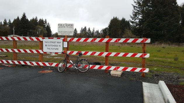
This property in North Albany, shown in February 2017, is in the 100-year flood zone. Any developer will have to obtain an assessment for endangered fish and orcas.
It sounds like a joke but it isn’t: From now on anyone wanting to build anything in the designated 100-year-flood zone in Albany will have to prove that the work won’t harm endangered species including salmon, sturgeon, smelt and killer whales.
That’s because some years ago various environmental groups sued the Federal Emergency Management Agency on the grounds that FEMA’s National Flood Insurance Program might endanger threatened species.
FEMA consulted with the National Marine Fisheries Service, which concluded in 2016 that yes, the insurance program — presumably by not preventing building in flood-prone areas — did jeopardize those species.
In 2023, four groups including Willamette Riverkeeper sued again claiming FEMA was too slow in doing anything about this. So now FEMA is telling jurisdictions that take part in the federal flood insurance program that they must make sure development in flood areas harms no endangered fish.
The upshot: The Albany City Council on Monday agreed with a city staff recommendation to require applicants for building permits in the 100-year flood zone to prepare a Habitat Assessment documenting that their project will achieve “no net loss” of any of those species.
In answer to a question from Councilwoman Matilda Novak, City Attorney Sean Kidd noted that the requirement would affect development on a collection of several parcels north of Hickory Street in North Albany. Seven years ago the Portland owners planned a big residential project on the property but so far have not followed through.
Nearly 2,200 acres in Albany are included in the flood hazard area. This includes the swath of Albany in the flood plain below Gibson Hill, as well as low-lying areas in the western, southern and eastern part of town.
About 1,400 acres are zoned residential, and about 300 are commercial or residential. There are 411 buildings in the flood hazard area with nearly $580 million in coverage under the National Flood Insurance Program.
The rest of the flood hazard area is zoned open space.
Doing a habitat assessment for any new building or expansion might not be simple or cheap. FEMA has published a long list of recommendations on how to go about it and what agencies to consult.
The government suggests that to save the expense of proving no harm to salmon, smelt or killer whales, it would be better not to build in the flood plain at all. (hh)

New Albany rule: Don’t harm killer whales
This property in North Albany, shown in February 2017, is in the 100-year flood zone. Any developer will have to obtain an assessment for endangered fish and orcas.
It sounds like a joke but it isn’t: From now on anyone wanting to build anything in the designated 100-year-flood zone in Albany will have to prove that the work won’t harm endangered species including salmon, sturgeon, smelt and killer whales.
That’s because some years ago various environmental groups sued the Federal Emergency Management Agency on the grounds that FEMA’s National Flood Insurance Program might endanger threatened species.
FEMA consulted with the National Marine Fisheries Service, which concluded in 2016 that yes, the insurance program — presumably by not preventing building in flood-prone areas — did jeopardize those species.
In 2023, four groups including Willamette Riverkeeper sued again claiming FEMA was too slow in doing anything about this. So now FEMA is telling jurisdictions that take part in the federal flood insurance program that they must make sure development in flood areas harms no endangered fish.
The upshot: The Albany City Council on Monday agreed with a city staff recommendation to require applicants for building permits in the 100-year flood zone to prepare a Habitat Assessment documenting that their project will achieve “no net loss” of any of those species.
In answer to a question from Councilwoman Matilda Novak, City Attorney Sean Kidd noted that the requirement would affect development on a collection of several parcels north of Hickory Street in North Albany. Seven years ago the Portland owners planned a big residential project on the property but so far have not followed through.
Nearly 2,200 acres in Albany are included in the flood hazard area. This includes the swath of Albany in the flood plain below Gibson Hill, as well as low-lying areas in the western, southern and eastern part of town.
About 1,400 acres are zoned residential, and about 300 are commercial or residential. There are 411 buildings in the flood hazard area with nearly $580 million in coverage under the National Flood Insurance Program.
The rest of the flood hazard area is zoned open space.
Doing a habitat assessment for any new building or expansion might not be simple or cheap. FEMA has published a long list of recommendations on how to go about it and what agencies to consult.
The government suggests that to save the expense of proving no harm to salmon, smelt or killer whales, it would be better not to build in the flood plain at all. (hh)
Tags: endangered species, ESA, FEMA, killer whales, listed species, salmon, threatened species