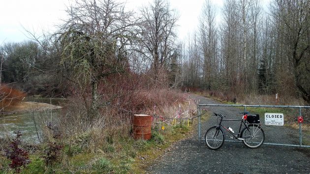
The end of the line, but only for motor traffic.
A year after it was closed for safety reasons, the last short segment of the road to the trailhead in the North Luckiamute State Natural Area remains closed to cars. And that’s he way it will stay, I learned when I left an email inquiry on the park’s website.
The Luckiamute — you see it on the left of the photo above — got close to the road when the river was running high last winter. The water threatened to undercut the road, so the parks people put up a gate and a sign. It looked about the same when I rode out there again last week, on Jan. 29, and I wondered how long the scene would be left that way.
Kevin Strandberg, the Gervais-based manager for state parks including the Luckiamute, was kind enough to respond to my question. “This area is prone to flooding and it will continue to flood and wash out the roadway,” he wrote. “Our current plan is to make the temporary parking area into a permanent parking area. We will be moving the main sign kiosk and large brown gate to the current parking area. We plan on improving this area with some native plantings.”
The so-far temporary parking area, complete with a portable outhouse, is to the right of the gate. Strandberg said it has an upside: “This new parking area is more visible and safer for users. A higher visibility location will discourage vehicle break-ins and illegal dumping.”
The two segments of the Luckiamute State Natural Area are northwest of Albany, off Buena Vista Road, and only about 10 or 15 minutes away by car. The north entrance is the gateway to a winding trail that leads through primeval forest all the way to the Willamette River. The change in parking area has made the hike a few hundred feet longer, but it’s still worthwhile. And on a fat-tire bike the extra distance makes no difference at all. (hh)

A very nice piece of public property and access. When the shade trees they planted years ago reach maturity it will be even better.
But… any more word on the river access for canoes and floaters?
Awaiting a response on prospects for the improved paddlers’ access. (hh)
If a picture is worth a thousand words, a map is worth a million:
http://www.oregonstateparks.org/index.cfm?do=main.loadFile&load=_siteFiles/publications/luckiamute-12-30092807.pdf
For those who like written descriptions:
http://www.oregonhikers.org/field_guide/Luckiamute_Landing_Hike
Drove me up the wall until I saw the map. Maybe I hate the English language.
Lots more stuff, including aerial photos and a beautiful topographic picture derived from Lidar data – click the pictures for large versions:
http://www.luckiamutelwc.org/luckiamute-state-natural-area-enhancement-project.html
Now my questions:
Where is it OK or not OK to ride a bike, any signs? Or has it not yet been decided? The Luckiamute State Natural Area Master Plan (April 2009) says that decisions allowing bikes, horses, and hunting are outside the master plan process – see page 33:
http://www.oregon.gov/OPRD/PLANS/docs/Luckiamute_Final_Master_Plan_Web.pdf
I vaguely remember exploring there about 10 years ago, probably walking my bike on what was not quite a trail, seemingly in public domain, trying and failing to reach any river.