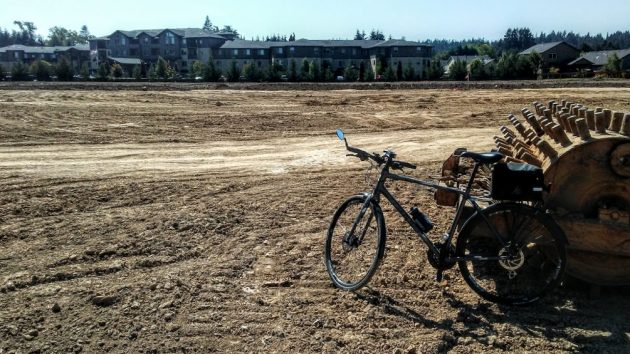
Looking west across the church-owned acreage at Hickory and North Albany Road on July 26. The Bonaventure senior housing complex is in the background.
For the past several weeks, earth-moving equipment has been busy near the corner of North Albany Road and Hickory Street, and passers-by wondered what was being developed on the vacant land.
A few of them asked me about it, and now I’ve finally gotten around to finding out. The answer, in short, is nothing yet.
The First Church of God, at Takena Street and 15th Avenue S.W., bought nearly 11 acres at the North Albany crossroads in the 1990s. The idea was eventually to build a church there, and that’s still a possibility in the long term.
But first a portion of the land had to be raised to get it out of the 100-year flood plain. (That’s the elevation in the valley that has a 1 percent chance of being flooded every year, based on history.) The church obtained city permits for floodplain development and grading and filling in 2018, and that’s the work that has now been done.
I caught up today with the Rev. David Shrout, the former pastor of the congregation who is overseeing the project. As a condition of the permits, he told me, the acreage has to be planted in grass to prevent erosion, and he’s trying to get that lined up.
When the planting is complete, the land may resemble a park. And until there’s development of some kind, Shrout told me the church intends to keep the site accessible to people in the neighborhood — for taking walks, for example, or exercising their dogs.
When I called Shrout Sunday night, I reached him at a campground at Fort Stevens near Astoria. A veteran bicycle tourist at age 68, he’s in the middle of a 17-day bike tour down the Washington and Oregon coasts from near the Canadian border to Brookings. (He posts daily updates on Facebook.)
As for the land at Hickory and North Albany Road, about 5 acres near the Bonaventure senior living complex is zoned for medium-density residential use, and the other half of the property, on the corner, is zoned mixed-use commercial, which also allows housing. On either of the two lots, building a church would require a conditional use permit.
The church has been paying property taxes on the land all these years. But as for development of all or part of it, there’s nothing immediate or definite in store. (hh)
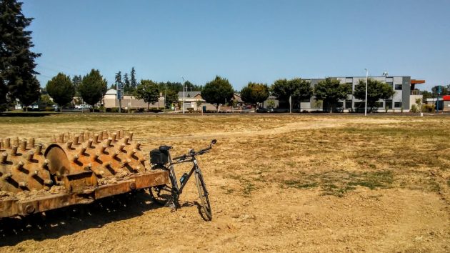
And looking east, toward the buildings across North Albany Road.

HH, has anyone questioned the wisdom of filling in 100 year flood plain at such a narrow point in the river? Where will the river go in a big flood now that we have filled in overflow channels?
Good question. I’ll try to get an answer.
As somebody who owned a house west of Albany for 40 years, the 100 year flood plain is no longer valid. The house flooded in 1964 before I bought it but not in 1996. Dams have made a huge difference in the 100 year flood plain and if you get a mortgage on that house today the feds will force you to purchase flood insurance but the chances of it flooding are minute as the 1996 crest would have to have been 2 feet higher.
The 1964 flood was 3.88 feet higher than 1996. There are 13 dams in the Willamette River basin. Of those the Cougar was built 1963-1964, Blue River in1969 and on the Santiam Foster and Green Peter were built in 1968. All the others were built before 1964. If you look at the river around Albany you can see gravel bars in several places. Hub City used to dredge the river but not anymore. The April flood in 2019 showed us something different because it was only major flood in the spring and it was 2.71 feet lower than 1996. This information came from FEMA.
Okay so the bike tour sounded interesting. I went to Rev. Shrout’s Facebook page for a look. I’ll have to go back. Thank you Hasso for always writing about something that gets my attention.
I with you @Patricia, the bike trip sounds very interesting.
My son and I rode Astoria to Brookings in 2018 (8 days) with Mr. Bauer’s cross country kids (LHS) and it was spectacular. A little nerve wracking in the Siuslaw Forest (narrow shoulder.) After Florence, the road is wide and traffic diminishes. Everywhere, a reminder of the great state we live in and that a bike is the best way to see it. Not just me, sayin’, lots of foreign tourists voting with their pedals.