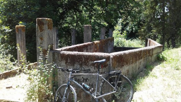
The irregular shape of this concrete formation makes it hard to tell what it was.
On a hillside just above the loop drive around Bryant Park, you can just make out a concrete foundation. Climbing up and taking a look, however, doesn’t get you any closer to understanding what this structure might have been for, back in the day.
Somebody asked me if I knew what it was. I didn’t, so on a ride this week, I pushed the bike up the bank above the road. Nothing in the shape of the remaining structure told me any more than that it was an old concrete foundation for something or other.
Given its location, would the parks department know anything about it? Rick Barnett, the park maintenance supervisor, responded that he didn’t. But, he added, “There is also a large concrete structure back in the trail on the northwest part of the park. That one looks more like a building. We have tried various ways (Museum etc..) to track down the answer but so far no luck. We would be glad to have a newsman throw it out there and see if anyone knew.”
Which is why you’re seeing this little story.
Among the others I asked about this was Gordon Steffensmeier, in the engineering section of Albany Public Works. He has access to aerial photos, and he took the time to check.
“There was no structure there in the 1963 photo,” he reported. “The 1975 photo shows a roof. In the picture below, that structure is the white roof above the ‘hand’ cursor in the photo. The area west of the structure looks like a pasture. My best guess is that the structure is somehow related to livestock?”
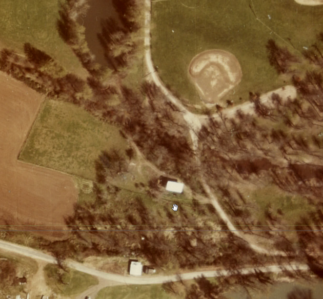
That white rectangle above the cursor could be the roof of the mystery building in this aerial from 1975. But what’s there today is not rectangular.
In any case, Steffensmeier reports: “By 1979 all that shows up is what is there today.”
As Barnett mentioned, there’s another ruin of a building on the northwest corner of the park. The 1963 aerial shows that one. Its location in the photo and its surrounding features on the ground suggest it was part of a gravel-mining operation on the bank of the Willamette.
If that’s so, it still leaves the mystery of the other ruin, the one on the high ground between the Bryant Park loop drive and Bryant Way. If anybody knows, all of us wondering about this would be grateful for a response in the comments below. (hh)

Has anyone asked Bill Stellmacher? He has lived in that general area for nearly 75 years.
Could it be an explosives bunker when the area was mined for gravel?
The area in the first photo looks like a baseball field.
Doesn’t look like Bryant Park even in 1975 pic never remember pond in the park
I played and explored back there when I was a kid 1956-58. There was an old sand and gravel loading bins back there. l’m thinking Albany sand and gravel or fifth street sand and gravel.
Years ago I also pondered what was at this site. The concrete walls appears to be some kind of water way for something. Surrounding the site I found refractory bricks with the name “AP Green” on them. These bricks are used in kilns but there is no evidence of a kiln or furnace at the site.
When first on the PD in the early 70s there was an ol’ farmer who kept cows on that mound closest to Bryant Way. He had a key to the lock on the park loop gates so he could drive in & deal with his cows that used that concrete structure.
In the mid-70s Hub City Concrete, at north end of Geary St, had a haul road from that riverside structure in Bryant Park, crossed the Calapooia River on a R/R flat bed bridge, up thru what is now the Senior Center, east on Water Ave winding thru the streets to their plant. One or two of the PD guys made extra $ being drivers for them. It was used only in drier weather.