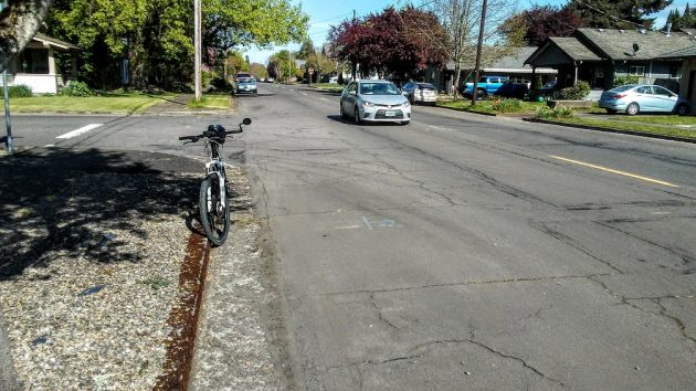
This is part of the stretch of Ninth Avenue to be rebuilt this summer.
Some time this spring or summer, a contractor for the city will start tearing up the west end of Ninth Avenue in Albany in order to rebuild it. Assuming, that is, that the caronavirus outbreak doesn’t change the plans.
On April 8 the city council awarded the contract to K&E Excavating of Salem, whose bid of $1,387,485 was the lowest of four.
The contract calls for five blocks of Ninth, about one-third of a mile from Broadway Street to Elm, to be rebuilt. That includes curbs, sidewalk repairs, storm drains, and landscaping. It also includes replacing a deteriorated water line with a bigger one. The street, water line and storm drains are to be completed by Sept. 4, and street trees and landscaping by Nov. 13.
Why reconstruct that section of Ninth, which to the untrained eyes of passing motorists and cyclists looks to be in better shape than the rest of Ninth between Elm and Ellsworth, and certainly better than many of the numbered streets east of Lyon?
City Engineer Staci Belcastro said Ninth was built in 1937 and a storm drain pipe was installed down the middle in the 1980s.
“Over the years, this section of Ninth Avenue has seen multiple overlays,” she wrote in an email, “but it has reached a point where both the asphalt and road base is failing.”
She also provided this: “Ninth Avenue is classified as a collector street and has a pavement condition index (PCI) of 39. Without getting too detailed, streets in Albany are classified in three categories: arterial, collector, or local. Arterial and collector streets see higher traffic volume compared to a local street. Examples of an arterial street include Waverly Drive and Queen Avenue; examples of a collector street include Marion Street and Jackson Street.
“Following discussions on the condition and maintenance of Albany’s streets, Council set a goal in March 2017 to maintain all arterial and collector streets to a fair or better condition (minimum PCI of 60). Ninth Avenue, with a PCI of 39, is in serious or very poor condition.”
If you want more details, Belcastro points out that information on Albany’s streets and past staff presentations to the council can be found at https ://www.cityofalbany.net/streets.
As for the rest of Ninth, the section west of Ellsworth which is breaking up in some places, a few months ago Belcastro suggested that it be included in a street reconstruction bond measure to be put to the voters. But the council did not follow up on that idea. (hh)

How many crumbling “Locals” equal 1 “Collector”?
30, 40, 50…..?
Greetings,
A group in Corvallis is making masks, tyvek gowns and plastic face shields in a well organized way. Looking at other gofundme sites, they are one of 6 or so in the country that has done the most. The Corvallis Advocate has done an articel but the GT/DH hasn’t yet. Would you write something up so we can get more volunteers.
https://www.corvallisadvocate.com/2020/masks-gowns-and-shields-heroes-of-corvallis-sewing-brigade/
https://signup.com/client/invitation2/secure/3248620/false#/invitation
https://www.gofundme.com/f/face-shields-for-health-workers?viewupdates=1&rcid=r01-158673192216-50881b0492af4c2e&utm_medium=email&utm_source=customer&utm_campaign=p_email%2B1137-update-supporters-v5b
Many thanks
I asked Mr K how the city of Albany was going to ever rebuild their roads and he suggested a city study which I didn’t bother to read but that cost is over $4 million per mile. How many miles are in the city Ray K and does the study address the cost in current or future dollars?
“…a city study which I didn’t bother to read…”
And if you’re not going to read the provided information, why bother to ask the question?
https://www.cityofalbany.net/streets/basics
“In 2017, the City of Albany maintained 187 miles of paved streets, 20 traffic signals, 7,290 signs and 61 miles of painted pavement striping. These numbers increase every year with new development and planned street improvement projects.”
“…does the study address the cost in current or future dollars?”
I’ll let you read the information found here: https://www.cityofalbany.net/streets/goals-costs
So I read the blurb which said it takes $5 million to maintain the roads which they don’t have-doesn’t say how much they take in. How does this prepare the city to replace roads if it currently takes $4 million to replace a mile of road.
“How does this prepare the city to replace roads if it currently takes $4 million to replace a mile of road.”
Bingo! You figured it out… It doesn’t and never has and never will completely pay for all the transportation infrastructure needed. But that’s OK. In our infinite wisdom we voted down an absolute minuscule 5-cent gas tax, so we’re good to go! If you want to see what the current 5-year Capital Improvement Plan is go here:
https://www.cityofalbany.net/pw/engineering/capital-improvement-program
“Pavement Management 101 Whitepaper”
https://www.cityofalbany.net/images/stories/publicworks/streets/funding/docs/01232017_pavement_management_101_whitepaper.pdf
I don’t know if that’s the study, but it mentions “reconstruction” costing “$200 – $230 per sq. yd.” For our grossly-oversized 40 ft-wide streets, the middle of that cost range is about $5.045 million per mile. That times a zillion miles = a bazillion (presumably 2017) dollars.
Many people who call themselves “conservative” and “practical” seem to like lots of nice, big roads everywhere. Maybe it’s time to start thinking about more imaginative and genuinely practical alternatives.
How about simplifying the categories to two: “Road,” a place to move traffic efficiently from one place to another, and “Street,” a place to create wealth. In this system, cars would have to move so slowly on streets that no one could ever get hurt. And on roads, there would be no homes, businesses, or other places where people need to congregate and spend money. What we have now mixes people and motor vehicles in a dangerous and non-productive way.
Bravo! This is one of the best sketches I’ve ever read for how to deal with THE PROBLEM (without the more radical changes I favor).
There are many ideas for creating “streets” which can be found on any city-planning website.
Good “roads” exist in a few places. One of my favorites is Rock Creek Parkway in Washington, DC (looking back to when I lived nearby in 1968). It was 4 lanes, one way in-bound morning rush-hour, one-way outbound afternoon, two-way at other times. Speed limit (and practical speed) 35. It moved a vast amount of traffic between near-downtown and a less-dense uptown very efficiently and pleasantly with no billboards, no stops(?), no driveways, no business, no houses, but lots of curves and beautiful scenery.
“Roads” (at 35-45 MPH) could take the place of newly-needed freeways at much lower cost, taking much less space, being much more pleasant to nearby communities. There’s a small, tantalizing hint: 99W north of downtown Corvallis, but the speed limit(50) is too high, and some of the roadside is shabby and dirty.
On second thought, it will take more than standard city-planning to get to where “cars would have to move so slowly on streets that no one could ever get hurt.”
Nevertheless, that’s the way to a better world.