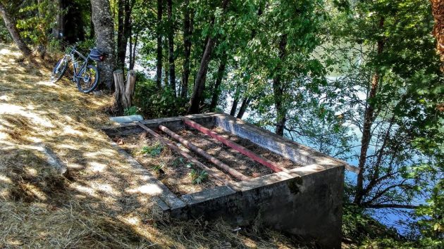
No one was sitting on these walls by the river when the photo was shot on Aug. 1.
For years, three or four times a week, I have passed this concrete ruin by the side of Albany’s Dave Clark Riverfront Path without thinking anything about it. The other day I finally wondered what it was a ruin of.
It looks like kind of a concrete box, about 8 by 10 feet, open at the top, filled with dirt, and crossed by a couple of pipes and a steel beam.
If you go by there when the weather’s fine, you will occasionally see people sitting on the walls for a smoke, or having a conversation or a snack. And why not? Sitting there, you get a nice view of the Willamette through the trees.
So what was it? Alas, I have no idea and have not been able to find out.
In the engineering office at City Hall, Gordon Steffensmeier came up with a blueprint for the construction in 1951 of the city’s Riverfront Interceptor, a big sewer main that runs along the river’s bank. The plan shows a rectangular shape where this box still is, along with a couple of smaller structures on the inland side and a concrete sidewalk connecting them.
On the land side, the plan shows the big building of the Borden Company. The building is still there and now houses the Deluxe Brewing Company.
The late Robert Potts showed the building in the third volume of his “Remembering When” photo collections of old Albany. He called it a “milk condensery” and said it was built in 1929. The Borden Western Company ran it until it closed in 1963.
So, what about that concrete box?
“My bet,” Steffensmeier said, “is that it had something to do with the Borden Company. Maybe some sort of discharge to the river?”
Maybe so. And if anyone knows for a fact what it was and what purpose it served, I’d be grateful for a tip. (hh)

Thanks for posting this Hasso. I have wondered for years what that box was for walking past it so many times.
OOO thank gawd it wasn’t some kind of 50’s atomic safety device! Our river bank is full of interesting stories. In the 70’s, young artifact hunters would even come under some 1st Street buildings hunting for glass jars. They were using old street maps. In fact on, Water Street where the building supply firms lot is now sited there was a gulch that was used as a dump & Water Ave didn’t go east! Artifact hunters would dig at the bank and along east of the bank doing their hunting. It was that way in Nov ’71 when I was hired!
What does the river side base look like? Could be a water intake/pump station.
If it doesn’t cost to play, I would guess that it was some kind of wash station. That would depend on some sort of an outlet near the bottom on the river side. It might have had a partial filling of washed river rock as a filter, or not, and it may have been filled with soil to “de-certify” the operation, if that was required back then or just to remove a safety hazard. The solution to pollution was delusion in the day.
Delusion is fitting, but wasn’t the phrase “… dilution”?
Here’s a photo from the air dated 7-8-1947. https://digitalcollections.ohs.org/uploads/r/oregon-historical-society-library/9/c/7/9c7bf10869d452f147e5abac8b08f40ee6c2b0caec5263fd5aa232dfde417707/7c3b72d6-3c2d-44e6-b266-11d789d1c63e-OrgLot1284_1237_5.jpg?token=d4fb269852e9b5e1c5a1c00260d3197ba0ea1407224d17a7d44fc6593c423544
you can zoom in and see the log storage in the river, and ramp to river. My guess is though like others, that this was water intake for one of the businesses along that stretch